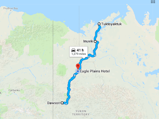
50 - Dawson City to Inuvik
On Google Maps
Don't forget, you can always find our current location here.
From Dawson City, we headed the 20 or so miles to the start of the Dempster Highway. The Dempster is another unpaved/gravel road which takes you north to the Arctic Circle and Inuvik, and more recently, all the way to Tuktoyaktuk, and the shores of the Arctic Ocean.
It had been rainiing on and off as we took a left on the Dempster and headed north. The road was not in great shape. Tons of teeth rattling potholes and washboard ridges. We found that we could rarely go above 25mph, and we often went quite a bit more slowly. Our poor little Winnefred took a real beating. Within 15 minutes of starting on the Dempster, an enormous tour bus passed us coming the other way at a very high rate of speed. Next thing we knew mud and gravel washed across our windsheild, blinding us for a minute til we could clear it with our wipers. That's how our windsheild cracked. The crack got longer and longer the more we bounced along.
A few bone-jarring, bouncy hours later we were driving along and a pickup truck heading south flagged us down to tell us the road ahead had been washed out and it was un-passable. We continued north, thinking we would get as far as we could and just camp for the night. We got as far as a road block and a detour to a makeshift gravel lot to camp in for the night. As it turned out, there were about 6 or 7 of us stranded travelers camped for the night. It rained most of the night and into the next day. Probably not great for landslides and washed out roads. We felt very lucky that we were totally equipped for impromtu overnight camping. We ended up meeting a new friend, Lonnie. He's a wonderful story teller and an overall generous person. He was traveling solo in his pick-up truck which he totally had outfitted for living on the road. He set up his portable outhouse for everyone to use, how nice is that?!
Our makeshift campsite that we shared with other travelers:
In the rain the next day, we got the word that they had opened a single lane and that if we didn't go right then, they were closing the road completely for at least 24 hours. Needless to say, we were ready to get moving.
We stopped in Eagle Plains for the night. They had a few spots with electric which we needed. Between the low angle of the sun and all of the rainy overcast weather we'd been having, our solar panels were not keeping up too well. We plugged in and woke to beautiful weather.
We had to stop to fill our tanks with our spare gas:
In Eagle plains:
From Eagle Plains, it wasn't long til we passed into the Arctic Circle. Then, it was 2 ferry crossings and a long day's drive on the bumpy road and we pulled into Inuvik around 11pm, still light out, of course. If you find yourself in Inuvik and hungry at 11pm, check out The Roost. We couldn't believe they were still open! Great cheeseburgers! We also ran into a couple of motorcyclists that we had shared a ferry with earlier in the day. Nice guys, also headed for Tuk. Quite a few motorcycles and many RV's and truck campers. We also passed maybe 20 or so cyclists on the bumpy road.
The town campground was full. We ended up parking for the night at the visitor's center. The next day, we saw a sign posted there that said "No Overnight Parking," oh well. Nobody knocked on our rv door or anything. Anyway, We barely managed to get a camping spot the next day, this campground has been very busy since the road to Tuk opened.
Flat tires are pretty common on this road, be sure to carry 2 spares
We saw all types of vehicles, this was the only convertible though.
The North Mart, a quasi-walmart of sorts
 After showers and washing the dust off of ourselves and our RV we got a great night's sleep in the campground. The next day, we decided to hang out in Inuvik, do a little grocery shopping and relax a bit. The next morning, we headed north to Tuktoyaktuk.


Comments
Post a Comment